Project Utilities
NOTE: Project Utilities are settings that apply to an entire Project and all Centerlines associated within that Project. They are first defined in the Seed File. When the New Project is created, it is created with these settings. You can modify these settings, per Project, under Project Utilities.
Project Utility Tabs

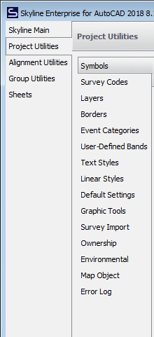
The Project Settings Include:
- Symbols - DWG block symbols
- Survey Codes - Code list for processing GPS collected points
- Layers - DWG layers included/excluded from project
- Borders - layout template for sheet data
- Event Categories - alignment event categories and descriptions
- User Defined Bands - event data layout and display outside of the Material band
- Text Styles - font, size and orientation of Skyline drawn text
- Linear Styles - weight and design of Skyline drawn linework
- Default Settings - program settings based on login username
- Survey Import - capture and process survey data
- Graphic Tools - change feature description, draw points and lines from survey data
- Ownership - property data the alignment passes through
- Environmental - environmental data the alignment passes through/near
- Map Object - consuming Object Data from MAP/CIVIL3D feature tables
- Error Log - project process/error record
Individual Tab information will be covered in other articles.
Edited by Noah Waters 9/15/22